Activity 2: Where Will You Build a Research Station on Mars?
This is an open-ended activity that requires students to use topographic maps to select a site to explore. Students should justify their site selections and describe what hazards they would see at this site. This will be a journal entry for their portfolios.
Purpose
Students will choose a site to be their research station.
Objectives
Students will:
- Explain how topographic maps are useful in planning a research station site.
- Select a site to be their research station.
- Describe why they chose this location.
- Write a plan that describes their research.
- Identify the hazards surrounding their research station.
Materials
- Topographic maps of Mars' eastern and western hemispheres
Engagement
Ask your students, "If you could pick the first research site on Mars, where would it be? What do you want to learn at that site? Why?"
Exploration
Distribute and review maps. Then circulate among student teams and encourage them to:
- Review topographic maps, latitude, longitude, contour intervals and scale.
- Describe the first thing they would do when they stepped onto the surface of Mars.
- Discuss what a research station on Mars might look like.
- Design a plan to gather information in their research areas.
- Describe the expedition equipment and who would be on their research team.
If students do not have enough background to suggest a location for their research stations, you can encourage them to consider the search for life, water or mineral resources as reasons for selecting a site. Students might construct a weather station to monitor seasonal changes, or they might consider collecting information about Mars' geologic history, identifying natural hazards, and analyzing rocks and minerals to be used in building and maintaining a permanent research station.
Explanation
- You are in charge of building a research station on Mars. What will you name it? Write its name in Table 1. Answers will vary.
- Select a location for your research station, mark it on your map and write its longitude and latitude in Table 1. Answers will vary.
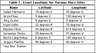
Note to teacher: On Mars the longitude extends from 0 degrees to 360 degrees west.
At a contour interval of 1 kilometer, many of the common features of Mars are not apparent. The heavily cratered highlands of the southern hemisphere are only represented by Argyre Planitia and Hellas Planitia. The enigmatic dry river channels, canyon landslides and faults cannot be shown at this scale.
You may want to have students locate their research stations at the two Viking Lander sites. Viking Lander 1 touched down in Chryse Planitia at 22.5 degrees north and 48 degrees west. The Viking Lander 2 site is in Utopia Planitia at 48 degrees north and 225.6 degrees west.
- What is the elevation of your research station? Answers will vary.
- Why did you select this site? Answers will vary.
- What research would you like to do here? Answers will vary.
- If you looked out from your research station, what would you see? Students may describe large landforms, surface conditions, or sky color and clouds.
- What hazards should you prepare for? Students may suggest geologic, atmospheric, climatic or other hazards.
- Select four people to work in your station and describe their jobs. Students should consider a variety of jobs to support their station as a laboratory, home and communication center.
- Do you think it is better to use robots or people to explore Mars? Explain your answer. Students may suggest robots as not needing many resources or people as being able to make immediate decisions.
- What does your station look like? What kind of materials is it made of? Also describe your research and the supplies you will need. Students should be reminded that Mars is a hostile environment and that the life support systems would limit the type of research or supplies needed to complete their research.
Elaboration
In portfolio assignments, students should discuss their research objectives and the problems they might encounter in achieving them. You can compare the proposed exploration and research to the exploration of Earth's seas and the Antarctic. Address problems that Earth explorers face that are similar to problems students will face in exploring Mars, such as supplies and a hostile environment.
Future missions to Mars in this decade include a Russian mission, Mars '94, which is scheduled to carry small meteorological stations and penetrators to the surface and place a spacecraft in orbit. In 1996, United States scientists plan to launch the MESUR (Mars Environmental Survey) Pathfinder, which will carry a small rover. Russian scientists will also launch another mission in 1996 (Mars '96). This mission is scheduled to carry an innovative balloon containing scientific instruments and a highly mobile and capable rover.
The Mars missions of the 1990s are remarkable because they involve several nations in the experiments. For example, French scientists are building the balloon for Mars '96, which is scheduled to carry an instrumented guide rope (the Snake) designed by The Planetary Society.
Evaluation
Students will:
- Plan a trip from their research stations to the Viking 1 Lander that is located at 22 degrees north and 47 degrees west.
- Suggest research that might be done at the icy poles of Mars to help understand past changes in climate.
- Compare the hazards of a research station in the Antarctic with one on Mars.
- Write a proposal to NASA explaining where they selected their research site and why.